GIS map resources
- See all maps
When using a GIS map, use the layer button to select the information you are looking for in your chosen area.
Image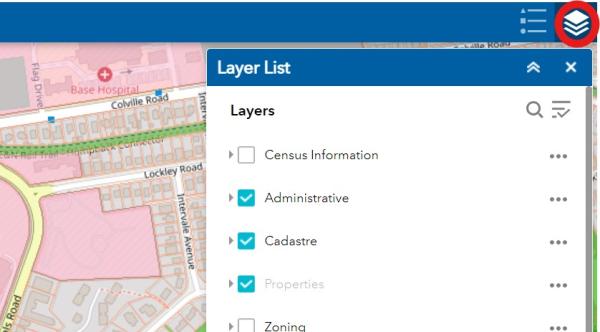
Planning and Zoning
These maps may be used to identify parcel size, zoning, present land use, proposed land use, Development Permit Areas, tsunami hazard zones, heritage designation, topography, and infrastructure. The layers list is located on the top right corner.
- Property parcel information
- Zoning map
- Schedule A-1 Zoning Map
- Schedule A-2 Small Scale Multi-Family Housing Overlay Map
Municipal Boundaries and Regional Context
Tsunami Preparation
- Esquimalt's Tsunami Hazard Zone map
- Greater Victoria tsunami planning map
- Saanich Peninsula tsunami planning map
Getting Here and Getting Around
- So Easy to Explore: Tourism Township Map
- Township Walking Tours
- Esquimalt street map
- Google Earth map
- BC Transit Greater Victoria regional map